December 2008 - Feburay 2009

December 2008 - Feburay 2009
Route: Tahiti --- Easter Island (more paradise in the middle of the ocean). Easter Island --- Santiago (then travel overland - don't ask me how - to Lima in Peru, seeing the Inca trail of course). Lima --- Mexico City (have fun in Mexico for a few weeks - including my 30th birthday party). Mexico City --- London

29 January 2009

Puno

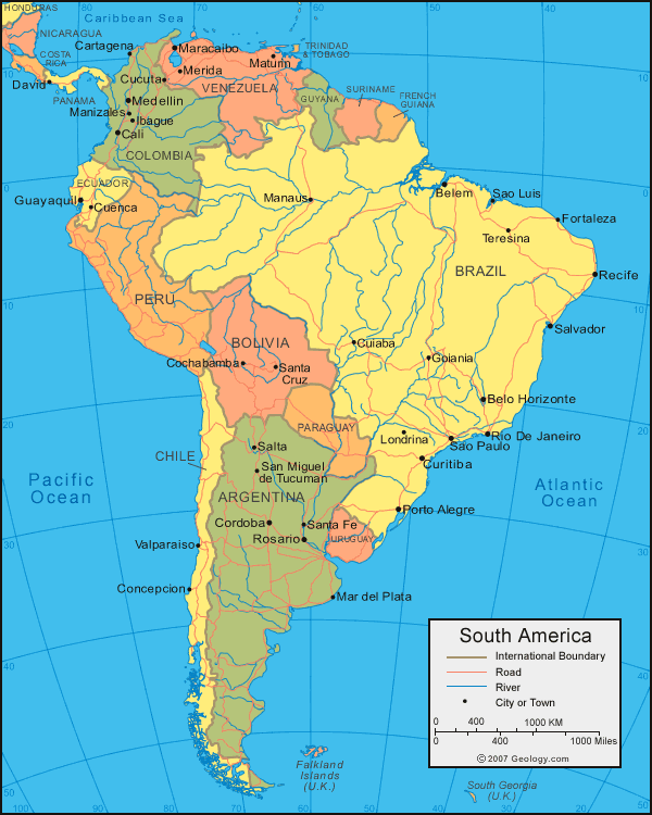
Puno is a relatively large town on the west bank of Lake Titicaca. It is high in the Andean mountain range – the lake itself is 3827m above sea level, and parts of Puno rise above 4000m. Puno has a pleasant enough town centre, with a few nice bustling streets, but Lake Titicaca was the main reason we came to this part of Peru.

The high altitude may lead to impressively blue skies and clear (i.e. thin!) air, but there are a few definite disadvantages to venturing this far above sea level. The most obvious is the risk of Altitude Sickness (or Mountain Sickness) – physiological changes in the body in response to the low oxygen concentration in the air can cause severe problems for some people. Gary and I were both fine with the altitude, especially as we’ve been popping up and down to the Altiplano in Chile and Bolivia for weeks now! But we still felt a bit short changed of air sometimes if we exerted ourselves. It’s a strange feeling to get out of breath when climbing a few steps – makes you feel really unfit! Actually we spent one afternoon climbing up one of the mountains overlooking Puno to a 4000m Mirador (view point), so there were a few hundred steps to make us feel unfit… the spectacular views over the town and lake were worth the effort though!

The second major drawback to the high altitude was the temperature. In the day the strong sun beats down over Puno, leaving you feeling warm – and frizzled if you don’t use enough sun tan lotion! But as soon as the sun drops behind the encircling mountains the air becomes icy. We were visiting in the summer, and within 20 minutes of sun-down the temperature would fall way below zero. The locals respond to these contrasting temperatures very oddly – they seem to wear 20 odd layers of clothing all the time! We found this barmy – they must absolutely roast in the heat of the day, and probably still feel chilly at night as there is one thing they certainly don’t do – heat the buildings. No fires (unless for cooking), no radiators. Basically Puno seems to have no heating of any kind in its buildings. Which leads to some freezing nights shivering under the 5 layers of blankets supplied by the hotels!

Three nights of shivering was enough for us (well, me really – Gary seems impervious to the cold!). But at least as a reward we managed to see a truly remarkable part of the world. Lake Titicaca is vast, with a surface area of more than 8500 square km it is over 15 times the size of lake Geneva in Switzerland. And although the views from the hills around Puno are impressive, most of the main body of the lake lies out of sight around the headlands from here! it is only really possible to appreciate the size of the lake by going on a boat to visit some of the islands. During the hours needed for the small boats to chug across the water it feels like you’re venturing out onto an ocean… well, the distant shores are certainly too far away to see with the naked eye!

We wanted to visit Isla Taquile, a large inhabited island near the centre of Lake Titicaca. Unfortunately the only way to get there without arranging to stay with locals on the island was to go in a boat with a tour group – which meant we had to use our ingenuity to get away from the guide! Actually this wasn’t possible at first as the boat stopped at the Uros floating islands on the way to Taquile. These tiny man-made reed islands literally float on the surface of the lake, anchored in place to form small communities. There are over 50 floating islands, each with its own group of houses and fish farms, and some with schools and communal buildings. The people who live on the Uros islands must spend all of their time rebuilding them - the reeds rot away pretty swiftly. Well, the locals probably devote all of the time they have left after ‘putting on a show for visitors’ to rebuilding islands. Although seeing the floating islands was remarkable, and stepping onto the decidedly squidgy reed-ground was weird, we actually found this part of the trip pretty painful.

Gary and I hate being headed around or lectured to – we like exploring strange places! So if we are forced to use a tour for transport we get away from the group as soon as we can (usually within seconds of leaving the bus) and wander around as usual. But in Uros this was impossible – the reed islands are tiny! As a result we were forced to hear the excruciatingly long lecture of a guide who a) thought far too much of himself, b) had really bad English, and c) talked really slowly, often repeating himself, for a long, long time… Not good! This bloke really liked the sound of his own voice. Eventually he stopped, and then we escaped to wander around the tiny island, and capture nice photos from the roof of the boat. Luckily from here on we were able to escape the package – when the obnoxious guide tried to heard everyone onto a ‘traditional reed boat’ we just refused to move from the roof of the transportation boat (meaning we didn’t have to pay for a ride in a small boat packed with people, and so we got far better views of the floating islands when our transportation boat moved off to pick everyone else up!). And then by staying on the roof of the boat as it moved towards Isla Taquile we avoided the commentary we’d have had to endure inside, and had stunning views of the vast Titicaca Lake. Much better!

Our escape from the evil self satisfied guide continued on Taquile. After the boat docked we made our way up the steep side of the island to the main square of the tiny village (dodging plenty of kids trying to sell braided bracelets en route). Here we swiftly made our escape from the controlling guide who really wasn’t happy about it. He told us to ‘stay near here’ – to which my smiling sarcastic response was ‘No! That would be boring! Much better to explore!’ (I was annoyed with him by this point). He clearly wanted to earn commission by making us spend money in gift shops and restaurants! Instead we spent a lovely few hours walking along an isolated path at the north side of the island, past hundreds of agricultural terraces cut into the side of the steep slopes. The green of the cultivated terraces with the deep blue lake and vivid sky behind were particularly pretty. It was almost a shame to have to return to the boat for the long trip back to Puno – but then if it was cold by night at the edge of the lake I dread to think what it would be like after dusk on Isla Taquile!

Puno Pictures

This is a wonderful lagoon complete with a flock of flamingoes that we passed on the bus trip from Arequipa to Puno. We were really lucky - we were seated at the front row on the second floor of a panoramic-view double decker bus, so we had wonderful views of mountains, lagoons, lakes...
This is the wondefully reflective Lake Titicaca seen from the nice new waterfront esplanade at Puno. This photo really makes the lake look much smaller than it is though!

You get a slightly better idea of the lake´s size if you climb one of the nearby hills in Puno. But the section of lake you can see behind me is less than a twentieth of the whole!


At the same mirador (viewpoint) there was a small tower with a giant Condor on top. You could climb the tower - you can see Gary looking diminutive beneath the Condor´s claws!


This is Uros - fifty or so reed-based man-made floating islands are all anchored here, huts, fish farms, and all. What a weird way to live.


These are the beautiful Inca style terraces that adorn the slopes of Isla Taquile. The lake was a particularly nice shade of blue during our visit and the sky (as always at high altitude) was astoundingly clear - meaning the air felt particularly thin when climbing all the steps to get up to the terraces!


26 January 2009

Arequipa

Our first few nights in Peru were spent in the highly photogenic colonial city of Arequipa, one of the major centres in the southern part of the country. We were quite surprised to find that Arequipa was by far the most attractive city we’ve come across so far in South America – but then again, the most attractive features of Chile were definitely natural wonders. We were lucky enough to check into a hotel right on the beautiful Plaza Armas, the focal point of the town centre. So each morning we could have coffee on a wide communal stone balcony at the front of the building, overlooking the Plaza, Cathedral, and the towering El Misti volcano in the distance.

We were very lazy for the our few days in Arequipa – but it was such a nice place to wander around, stopping every now and then for coffee you can hardly blame us! The old town centre seems to consist almost exclusively of white stone buildings, evidently built during the years of Spanish colonisation. The Plaza Armas was particularly nice with its stylish twin towered Cathedral on one side and elegantly arched buildings completing a perfect quadrangle. The Plaza really came alive in the evenings when the buildings were brightly lit and swarms of people came to wander around the central gardens and fountains. The only drawback to this was the pickpockets – we had no problems, but that was mainly because we were very aware of the numerous thieves eyeing up everyone’s bags and pockets. Arequipa may be a very pleasant city, but to enjoy it you do have to remain alert!

I know we’ve only been in Peru for a few days, but already we’ve noticed distinct differences with Chile. The atmosphere is more frantic somehow – reflected particularly by the traffic! Arequipa is besieged by thousands of tiny cars whizzing here there and everywhere, most of them mini yellow tin-can cabs! You really have to dash across the street if you want to cross, as the cabbies will accelerate towards you as fast as they possibly can – and they close even big gaps in traffic remarkably quickly. Perhaps they prize running over grannies, kids and (of course) tourists as a national sport! But the slightly frantic feeling isn’t restricted to when you try to dodge taxis (or avoid pick-pockets). Even the crowds of people in the streets seem more active here somehow, which is a pleasantly lively but less relaxing environment.

Anyway, our next stop is the smaller town of Puno, which is on the bank of the massive Lake Titicaca, near the border with Bolivia. We thought it would be fun to explore the lake and its numerous islands for a few days, and Puno breaks up the journey to Cusco nicely… from where we look forward to seeing lots of impressive Inca ruins!

Arequipa Photos

This is the beautiful Cathedral at the northern edge of the Plaza de Armas of Arequipa by night. It looks great all lit up and sparkling - not surprisingly it is a favourite spot with locals as well as visitors. Below you can see the view of the plaza we had over breakfast from our hotel´s balcony... El Misti, the volcano in the distance, is very pretty! The other images show some lovely colonial buildings, mostly white and elegant, but some very colourfully painted in a Mediterranean style.


Another elegent archway - this was our favourite street in the centre of town for catching a quick coffee and watching the world go by!


Another view of the Plaza at night - this time from behind the grand central fountain (which was always covered with hundreds of pigeons!).


23 January 2009

Arica

Arica is the most northerly town in Chile – it’s only 25km from the Peruvian border. Actually it used to belong to Peru, until Chile confiscated it in a war in the 19th Century. Now it’s a lively little coastal town, again overlooked by the impressive mountainous cliffs and sand-dunes of the Atacama desert.

Our stop in Arica was for a brief 2 nights, as we now have to press on to Peru. But at least we had a chance to look around! Actually we were more or less forced to look over a reasonable section of town as the bus terminal is a good 3km from the centre – giving us a few long walks back and forth as we tried to work out exactly how to get across the border to Peru. Not the easiest thing! But look at the ‘Leaving Chile’ entry on the main Blog page for details on that…

One of the nicest things about Arica is its main thoroughfare – lots of cafes and small shops on a bustling tree-lined street leading down to the waterfront. It’s a lovely place to relax and people-watch over dinner. And from here it’s only a short walk through a few Plazas complete with fountains (and even an old black steam locomotive engine for some reason) to Arica’s most dramatic feature: a 150 odd meter cliff rising abruptly to tower over the town. It’s only a short climb to the top, but the views back over the town are great – complete with circling ravens (at least I think they were ravens!).

Anyway, now we have worked out how to cross the Peruvian Border we will give it a go tomorrow, and then let you know how we get on!

Arica Photographs

This is the very lovely view over the town and harbour of Arica from the top of a 150m cliff nearby. Behind me is (typically for this part of the world) a huge statue of Jesus and an archelogical museaum. Nice combination? But we prefered the view back over the water as the sun set! Below you can see the nice town centre with Gary standing under a tree looking sheepish!


Another lovely view over Arica (my turn to pose sheepishly for the camera). This was all made even more appealing by the huge numbers of large black birds that constantly circled around the cliff. I think they were ravens - they looked pretty large and sinister at any rate!

21 January 2009

Iquique

Our few days in Bolivia were stunning, highly memorable, but utterly shattering! In order to see the Salar De Uyuni and then get back across the border to San Pedro we had to get up at 3.30am two days in a row… painful. And then of course we wanted to move swiftly northwards through Chile towards the Peruvian border. So, unfortunately we had a brief stop-over in the small town of Calama and get up at the crack of dawn AGAIN to catch the bus to Iquique. By this time we were more than a bit exhausted, and so it was just as well that Iquique turned out to be a very pleasant place to have a break! After all, we are meant to be on holiday…

Iquique is a coastal town, perched on a narrow sliver of land between the sea and some dramatic volcanic slopes. I think most people come here for the beaches, but to be honest we preferred the lively town centre. But then again we have seen a number of beautiful beaches this year (particularly in Australia, Thailand and Malaysia), and Iquiuqe’s wasn’t quite amongst the best. And even on the prettiest beach in the world we’d probably play in the sea and then go off for a walk! We don’t make good beach bums!

As it happened the centre of Iquique was particularly nice during our stay. There was some sort of ‘International’ festival going on, which seemed to mostly consist of lots of stalls and booths in the main Plaza, each with it’s own National theme. OK, most of the countries represented were South American, and practically all of these were trying to make money by selling stuff… but even so it gave the place a very colourful lively atmosphere! My only complaint would be the noise – imagine about 7 getoblasters competing tenaciously with a huge PA system to see who could blast their Latino-pop the loudest… Not so good. Especially as by now we have developed a profound dread of some types of South American pop music – see the ‘leaving Chile’ post I’ll put on the main site in a few days for a good rant about that!

Anyway, now that we’ve recovered from our Bolivian exhaustion in Iquique we’ll move further north to Arica. And from there it will be a short hop to the border with Peru!

Iquique Pictures

This is the graceful arc of sand that makes up Iquique´s main beach - pertty enough, but not as interesting as the square at the centre of town! The pictures of Gary below give a good impression of the place, nice and lively, and with the beautiful blue sky typical of Chile.


Lots of nice Cafes overlook the Plaza - perfect to while away a lazy afternoon over a coffee, beer or Pisco Sour...


19 January 2009

Bolivia and the Salar De Uyuni

Bolivia is a land-locked country. Thanks to Chile – they took Bolivia’s coastal region away in the Pacific wars last century. Consequently there are no diplomatic relations between Chile and Bolivia, and the border between the countries lies at altitudes of 4500m plus in the middle of the Andes! So we were surprised to say the least that this border crossing was arguably the friendliest we’d ever seen. OK, the air was a bit thin and cold, but the border guards were frankly pleasant – which we know by this point is not normal!

So after being dropped at the edge of Bolivia by minibus and passing the pleasant immigration, we were picked up by a large shiny sliver 4 by 4 jeep. The Bolivian Altiplano is a spectacular place – beautiful and remote. So remote that I can honestly say we didn’t see a single tarmacked road in our 4 days in Bolivia, and that most of the time we travelled by dirt tracks. Luckily we and the four other blokes who shared our jeep were driven around by a very friendly Bolivian guy called Valerio who knew his way through the twisted tracks perfectly. Three of us were from the UK (Gary, myself and Nick, an English tour guide), there were two Aussies (Ben and James), and one Spanish bloke (Nachos – who with his good English became the perfect translator!).

We spent the first day high up in the Altiplano, reaching nearly 5000m above sea level at one point. The Bolivian side of the Andes is a vibrant place, even the barren volcanic mountains are every shade from black through purple, green, blue, red and yellow. Better still were the colourful lagoons. We passed the Lagoona Blanca with its white water, stunning mountain reflections and flocks of flamingos, but this was soon eclipsed by our next stop, the Lagoona Verde. The ‘Green Lagoon’ doesn’t have any flamingos – not surprising as the colour of the water is apparently due to a high concentration of arsenic… But the most fascinating thing about this lagoon was its colour, or rather its colours. When we arrived the still deep green water reflected the surrounding volcanoes beautifully, but 10 minutes later a pale opaque matt green had spread from one side of the lagoon to the other, completely stopping all reflections. It was incredible – we’ve no idea what caused the water to change but we have never seen anything like it.

Then it was onwards past twisted rock formations to a lagoon with patches of salt floating on the water and yet more flamingos, to bathe in a geothermally heated hot-pool on the shore. A warm bath with a wonderful view! Next we stopped briefly at the colourful Geyser Sol De Manana geothermal field (no true geysers here – but plenty of vigorously boiling mud pools and fumaroles… and a good whiff of sulphur!), before stopping for the night at the Lagoona Colorada (Red Lagoon). Here we hit the first snag of the trip – the hostel we were meant to stay in n the banks of the Lagoon was full, and none of us really fancied a night in the jeep in freezing cold… Fortunately the resourceful Valerio managed to negotiate us a bed in another hostel a little further on, but it did make us wonder why the company we booked the trip with hadn’t made reservations!

In a way we were lucky – we actually preferred the second hostel. OK, it was pretty basic accommodation. With no running water the toilets weren‘t somewhere to linger, and some heating would have been nice as the temperature at night was well below zero at 4500m! But on the plus side the location of the place on the banks of the red-pink boron-tinted Lagoona Colorada was incredible – just a short walk away from hundreds of flamingos, herds of llamas, salt deposits like icebergs… We spent the evening shivering along with a cluster of other backpackers, eating cookies and watching the brilliant moon rise over the volcanoes into a sky filled with the brightest stars we’ve ever seen.

The next day we passed the stone tree (a weird rock that looks, strangely enough, exactly like a tree…) to drive on past more beautiful lagoons in shades of white, blue, and even yellow! Complete with even more flocks of flamingos, brilliant white surrounding salt flats and overlooked by active volcanoes of course. This region of Bolivia is truly incredible. We spent the second night in a basic hotel in a small village with little more comfort – i.e. we had running water this time so managed a (freezing) shower! But although the lagoons and volcanoes we had so far seen were truly beautiful, they were completely eclipsed by the sights of our third morning.

The Salar De Uyuni is the largest Salt flat in the world. It is a massive expanse of perfectly flat brilliant white salt precipitate – so that as you drive across it you barely seem to be moving. We got up at 4am to watch the sun rise from the centre of the salt flat. It was spectacular – as the sky changed colour with the approaching dawn the true expanse of the salt flat was slowly revealed to us. It is huge! Snow-white salt forming a complex mosaic expanse stretching for over 25km into the distance in each direction. I hope the pictures below give some sort of idea of the scale and beauty of the place, but this is really somewhere everyone should visit if they get the chance. The salt flat (salar) is so perfectly flat and vast that virtually all sense of distance is distorted, leading to some very interesting perspective photographic opportunities! Have a look at me balancing on the apple or Gary climbing out of the rucksack below…

The Salar De Uyuni isn’t a perfect stretch of salt however – it has a few small rocky islands in its midst which only serve to enhance it. We visited the Isla De Los Pescadores (Fisherman’s Island), a rocky outcrop covered with hundreds of giant cacti! These monster spiky plants only grow a couple of millimetres a year, but the tallest were over 4m high. Then it was on to the exact centre of the salt flat to play with more perspective photographs (jumping over the jeep for instance…) before passing a hotel made entirely of salt on the way to the edge of the Salar and the small town of Uyuni. It was an amazing few days – OK, the long return slog back to the Chilean border near San Pedro De Atacama wasn’t so much fun, but our venture into Bolivia was certainly one of the highlights of our year so far. And that is saying something after climbing the Great Wall of China, swimming with sharks, wandering around the Taj Mahal, winning £2 in Macau, cycling to the Easter Island Maoi, driving to Milford Sound, being interviewed for Japanese TV at Toyako Onsen, and so on... Not a bad year!

18 January 2009

Bolivia Photographs

This was our first stop only 10 minutes from the Bolivian-Chilean border: Lagoona Blanca (the White Lagoon). The surrounding mountains were reflected particularly nicely in its still waters. The pink flamingos were very elegant as they wandered around feeding – even if they did run away swiftly as we tried to get closer for a photo! Cautious things.

Gary and me in the middle of the high mountainous desert region that stretches from Chile to Bolivia – and even northwards to Peru apparently. You get a good sense from this photo of exactly how remote we were during this trip.

The Lagoona Verde (another Green Lagoon) also reflected the surrounding volcanic peaks clearly as we arrived on its shores. The impressive thing about this arsenic-tinted lagoon was that as watched the reflective deep green waters turned a pale green, almost opaque shade. This spread from the far side of the lagoon towards us as you can see if you look at the two pictures of Gary and myself which were taken during the change. By the time the colour change was complete, the lagoon was a very startling shade of white-green, and there wasn’t a single reflection on its surface. Really weird!

You see… the pale green has definitely spread by the time this second photo was taken…

The high altitude ´Geyser field´. Not that there were any geysers here, but there we lots of nice bubbling muck pools, fumaroles, and pretty colourful mineral deposits. And no fencing or health and safety restrictions so you could wander where you liked!

These stunning flamingos lived by the hundreds on the Lagoona Colarada – a lagoon with strips of water shaded a vivid pink-red colour. This was apparently due to boron in the water… whatever it was I’ve never seen water anything like it. There were big chunks of salt deposited around the surface too…

… and plenty of llama grazing near the shores! This is where we spent our first, highly cold, but very scenic, night in Bolivia!

This rock is called the ´Stone Tree´. You can easily see why – it is rock, not petrified tree, but with the ´trunk´ and branching structures above it does look remarkably like a tree! There were lots of other weird rock formations nearby which were great fun to climb for an hour or so.

This is Villa Martin, the remote village on the edge of the salt flat where we spent our second night. Our accommodation wasn’t quite so basic this time… we had running water, yippeee! The small village itself had some fascinating terraces as you can see, complete with traditionally dressed women with long platted bunches dressed in bowler hats, colourful tops and unflatteringly bunched skirts.

This was the spectacular Salar De Uyuni (Salt Flat of Uyuni) at dawn. It was vast – we’ve never seen the sun truly rise on the horizon except over the sea. Beautiful morning sky, don’t you think?

As the sun rose the details on the salt became even more apparent. This section had a polygonal pattern repeated over and over, we’ve no idea why. The mountains in the distance looked wonderful too, and emphasised the size of the flat by being so tiny! Also, you can see in the foreground the wonderful cactus filled Fisherman’s island which we later visited (see below).

Perspective! I bet you didn’t realise I could balance on a giant apple so gracefully!

Or that Gary would encounter a giant rucksack on our trip – his escape wasn’t bad!

And below is Fisherman’s Island which had amazing views of the vast surrounding Salar De Uyuni, and terrific giant cacti! They completely dwarfed us!

And more perspective action – this time my jump ´over the jeep´ looks as if it’s about to result in the squishing of most of our travelling companions when I land!


17 January 2009

San Pedro De Atacama

As you travel northwards Chile you really start to appreciate the vast extent of the Atacama desert. OK, there are no rolling sand dunes like you would see in the Sahara, just miles and miles of barren, rocky mountains rising up from the sea to the high Altiplano of the Andean mountain range. It's pretty remarkable to think that although Chile is only 180km wide at most, in this distance the country rises from sea-level on the west coast to the 4000 odd meter Altiplano on the east boarder, with several volcanic Andean peaks exceeding 6000m! No wonder altitude sickness is something to be very aware of in Chile - ascending 4000m this quickly can cause real problems.

But fortunately neither of us had any trouble with altitude! OK, we did feel very unfit when we first ascended to the Altiplano - just walking briskly for 30 seconds left us quite out of breath! And climbing 5 stairs left us panting! It's a pretty weird feeling coping with the low levels of oxygen up there. Although the first time we ascended to the Altiplano was to see the wonderful Tres Cruces National Park from Copiapo, our main base for exploring this vast high plane was San Pedro De Atacama. San Pedro is a effectively a large oasis village situated in the middle of some of the most fascinating natural wonders in Chile. Consequently it has become something of a tourist haven... seeing loads of western visitors wandering around the dusty streets was a bit of a culture shock after visiting typical Chilean towns like Copiapo and La Serena. A little like when we visited Chang Mai in Thailand after spending months in China and Japan! But although San Pedro may have oodles of craft stalls, restaurants and hotels to cater for the tourists, it actually manages to retain it's own personality - it's full of adobe-walled thatched-roof buildings, cobbled streets, and a lot of life! Perhaps best of all, each small street offers tantalising glimpses of the surrounding desert and volcanoes, tempting you to explore this incredible region.

Which brings us to a slight problem. If you've read this blog for a while you'll probably realise that Gary and I enjoy travelling independently. We want to make our own way around the countries we visit, to get a better feel for the places. We avoid tours like the plague - we'll even happily walk several kilometres laden with all our luggage to avoid having to take a taxi! So up until now we've managed to get to all the wonderful things we've visited by walking, local transport, or hiring a car or bike. Unfortunately this wasn't really an option here. Chile may be well developed by South American standards, but up in the Altiplano the roads are barely tracks for 4x4 wheel drive vehicles, the distances are vast, and there are no signposts or reasonable maps! So the only way to explore the place is to go with a group... groan.

Although we really wanted to see the area, we dreaded lectures by guides, being forced to walk around in a group, shepherded from place to place - that would ruin everything. Fortunately we very quickly worked out ingenious ways to avoid all this - and saw all the amazing things around San Pedro using the tour for transport from place to place. It was easy - all we had to do was briefly say to the guide '...we've seen several salt flats / geysers / lagoons / etc before and just want to wander around' to be polite, and then we'd just walk off while everyone else in the group got a lecture! It was wonderful - we saw far more of the stunning region, avoided being shepherded around, and even corrupted some of the other travellers (they started to follow us on our walks at some points rather than being bussed around from point to point!).

Anyway, one day we wandered around part of the wonderful Atacama Salt flat, where salt with a high lithium content has precipitated to form beige/brown coral-like structures around a series of beautiful flamingo-filled lagoons. After this we visited two stunning blue-green lagoons high in the Andes, home to flocks of flamingos and herds of vicunas (wild llama-like creatures). The next morning we had a painfully early start to see the Taito Geysers. This was perhaps the highlight of our stay in San Pedro - the highest geyser field in the world contains over 200 holes that spurt water in to the air spectacularly... but only at dawn! Soooooo, to see them you have to leave San Pedro at 4am and travel for over 2 hours up into the mountains to the Geyser field - a slightly surreal experience of waiting outside your hotel in the pitch dark with a crowd of other sleepy travellers watching fleets of jeeps and minibuses drive around town picking people up!

Once we got to the geysers it was worth the effort, despite the sub-zero temperatures and the early start. We immediately dashed away from the rest of the group and our minibus to explore. I don't think any of the others in our group moved more than 10m from the bus and guide, which was such a waste as it was a wonderful geothermal field. Although the geysers themselves were not as spectacular as those we saw in New Zealand, they were far more numerous, and the lack of health and safety regulations here meant that we could wander ANYWHERE - right between spurting geysers and hotpools! Wonderful sense of freedom, so much so that we didn't know where to look first! We dashed about gaping at the geysers, taking loads of snaps and trying to keep warm as the sky changed colour with the approaching dawn. And when the sun actually emerged over the mountain side the transformation was spectacular: the clouds of steam created by the geysers and fumaroles were lit up, and the valley floor became a mosaic of different colours of silica deposits. Stunning! And to finish off our visit we stripped down to our swimwear (quickly as it was still freezing even after the sun had emerged) to bathe in a geothermally heated pool in the midst of the geysers. The warm water was great to play in... but getting out back into the subzero air wasn't so much fun!

Our last trip to the area around San Pedro was to the 'Valle De La Luna' - the Lunar Valley. This is a wonderful region where the red-golden rock has been sculpted by wind and water erosion over the eons to create a landscape like the surface of the moon. Wandering along the valleys was incredible - the weird, twisted, colourful rock structures and total desolation of the place were stunning. This was especially true at sunset, when we first climbed a rocky spur to get a great view over the valley, and then ran and slid our way down the back of a giant sand-dune formed down the back of the rocky outcrop! Great fun!

Anyway, now we will be leaving Chile for a few days to go to Bolivia. We've decided to visit the lagoons and Salt flats on the Bolivian side of the Altiplano, which are allegedly even more stunning than the things we've seen here. The only way to get there is by 4x4 jeeps, so we've signed up for one - and some very basic accommodation at high altitude in the middle of nowhere... it will probably be a sensationally cold, uncomfortable and beautiful trip! Can't wait!

11 January 2009

San Pedro Photographs

The central Plaza of San Pedro De Atacama - a beautiful view of a conical volcano in the background behind Gary!


This is a photo of me by one of the lagoons in the centre of the Salar de Atacama (Slat Flat of Atacama) - in the distance you can see a beautifully coloured volcano and some tiny flamingos! And the photos below show some slightly larger flamingos (with great reflections in the water), and the salt itself. The salt crystals were incredible - they formed coral-like structures about 30cm in height!


A beautiful blue lagoon - volcanos, flamingos, vicunias... the Alitiplato is stunning! This lagoon is at about 4300m above sea level, making the sky a particularly nice shade of deep blue too.


In the valleys just blow the Altiplano you´ll find a number of llama. The locals here still farm them for meat and wool (and make some very strange garments from the fabrics!)


The Tatio Geysers just before dawn. These antisocial spurters are only active from 6am to 8am... maning we had to leave San Pedro at 4am to see them. It was worth the early start though - look at the colours of the sky.


As the sun came over the mountains the clouds of steam issuing from the geysers were transformed! And the reflections in the pools of water were stunning.


Impressively high trails of steam issued from the geysers - so mush so that it was actually quite difficult to see the water squirted up! But then the temperature was about -5 degrees Centigrade so you´d expect a bit of water condencation. Gary is dwarfed by the clouds in this photo...


After seeing the Geysers we passed by yet more beautiful Altiplano scenary. This stunning shallow lagoon was homw to a flock of flamingos too. Below you can see the desolate landscape of the Lunar Valley... complete with giant sand due and wind twisted rock formations.


Copiapo

Copiapo is a small town nestled in the midst of the barren Andean foothills in the south region of the Atacama desert. The town itself is quiet and sleepy, but very pleasant. It’s odd to wander down the tree-lined streets – as you glance up to the surrounding mountains all the greenery vanishes, replaced by rocky desert. Quite a contrast! But the perhaps it’s surprising that the town has trees and plants at all as apparently it only rains once a year!

Although Copiapo is nice enough in its own right, the main reason we decided to stay here for a few days was to visit the surrounding area. This is the best point to reach the south part of the Altiplano – the high-altitude plane formed by a divide along the centre of the Andes mountain range that reaches all the way north to Bolivia. The Altiplano may be incredibly dry and barren for the most part, but any waters trapped here between the volcanic peaks form colourful mineral-tinted lagoons or evaporate to create eerie salt flats. And of course as it’s in the middle of the Andes the Altiplano is seriously high – most parts are in excess of 4000m above sea level and the some of the surrounding mountains top 6000m!

We decided to visit the Parque National Nevado De Tres Cruces, a newly created national park only accessible by four wheel drive vehicles. This place is completely out in the middle of nowhere (close to the Argentinean border which of course is only on the far side of the Andes), has dirt tracks rather than roads, and reaches altitudes over 4400m (where you have to start watching out for altitude sickness). So, along with three Swedes on a short holiday in Chile, we hired a pleasant diver and a huge four wheel drive truck, and promptly whizzed up into the mountains! Copiapo is only 300m above sea level, so we had to ascend a very long way, passing barren hills, creepy abandoned mining towns, and even the occasional oasis where plants and trees would cluster thickly around a tiny water-source, surrounded by completely inhospitable desert mountains.

It took a while to get up to the Altiplano, but it was worth the wait. It’s an incredible place – we’ve never seen anything like it before. The mountains may be barren, but the high concentrations of minerals they contain give them multi-coloured hues. The slopes of each mountain ranged in colour from black and grey shades through purple-blues and greens, to red and yellow hues. And even at 4000m with virtually no water, freezing temperatures and a very low air oxygen level some plants still managed to grow! OK, only clumps of dry golden grass, but impressive none-the-less. But perhaps one of the most striking things about reaching the high altitude was the beautiful deep rich-blue colour of the sky.

While driving though the spectacular Altiplano we visited two lagoons. The first, Lagoona Santa Rosa, was the home to flocks of flamingos! They had a stunning home – the crystal blue lagoon lay next to a pure white salt flat, surrounded by red-brown hills and nestling under the snowy peaks of several volcanoes. We wandered around the waters edge (trying not to scare the flamingos away) before having lunch at a small hut on the side of a mountain, greedily watched by a mountain fox. Afterwards it was back into the truck to bump up and down hills along twisting dirt tracks towards the Argentinean border and the second lagoon. Lagoona Verde true to its name was a beautifully rich green-blue colour, again surrounded by spectacular mountains. The high salt concentration of the water gave the shore of the lagoon a white crust, which contrasted brilliantly with the deep hues of the water. But best of all, several volcanic hot-springs bubbled up near the waters edge, forming steaming pools before trickling down to feed the icy cold lagoon. A nice place for a quick foot bath while enjoying the scenery!

It was a shame to leave the Tres Cruces National Park – even if on the way back we saw some picunias (strange quadruped things related to llamas) and crossed a customs post designed for people coming from Argentina. Here our driver skipped the queue by tossing a bag of chocolates to an official he knew, and then opening a side track and driving the truck around the complex! And then it was back down, down, down to Copiapo. As I said, we were really very sad to leave, but at least our next stop will be in San Pedro De Atacama, a northern oasis village with easy access to further parts of the Altiplano! Apparently there is even a geyser field nearby!

10 January 2009

Copiapo Pictures

This is one of the small streets of Copiapo. As you can see, although Gary is right by a nice green tree, look just out of town and the hills are spectacularly barren! And there are hundreds and hundreds of miles of this desolate, mountanous Atacama desert. Below you can see both of us in a ghost town on the way to the Tres Curces National Park... an old mining town abandoned over 100 years ago. Spooky place!


Lagoona Santa Rosa! Snowy volacanos with a sparkling white salt flat below them - and of course the pale blue lagoon and red hills. Very colourful place! Especially if you see the flamingos feeding in the shallow water.


This is also Lagoona Santa Rosa - this time with some clumps of marsh grass at the edge of the lake. We wandered around here for ages - lovely place.


Here Gary is standing on the salt-encrusted shore of Lagona Verde. This lagoon is almost blue-green in colour.


And although Lagoona Verde doesn´t have any resident flamingos, it does have several hot springs along its shores. The geothermal pool in this picture has water about 30 degrees warm - and the minerals stain the underlying rock shades of orange and yellow. Beautiful contrast to the surrounding white salt or the blue lagoon!

Another picture of both Gary and me - thanks to the very friendly trio of Swedes we visited Tres Cruses with!